
BEAT 4 – LAMPETER
OVERVIEW
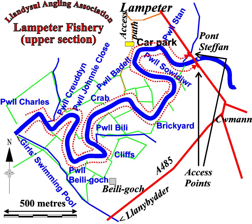
This is one of our most scenic stretches, with rich ranunculus weedbeds and a fine range of bankside trees and plants. It is almost entirely double bank fishing (please refer to maps below). The water is very lightly fished.
The beat includes several famous and productive salmon and sea trout pools including Pwll Sowldiwr, Pwll Bili, Pwll Beili-goch and Pwll Felinfach. In all, this fishery extends over a total of eight miles – enough water to explore for an entire season.
Whilst predominantly being best for brown trout, sea trout (sewin) do also make their presence known, especially later in the season. This water can also be excellent for salmon and are always worth targeting towards the end of the season or when high water prevents fishing further downstream. There’s a lot of water to explore, so do take the time to walk sections during low flows to educate yourself on the pools, features etc.
The banks are generally fairly clear, due to grazing in the area. However, the water is very lightly fished, so there is dense bankside vegetation in sections, reflecting the wildness of the area and river in general. A lot of this provides fantastic habitat for the fish.
Some history; a lot of the water that now comprises the beat stems from an old club – Lampeter Angling Association – that joined Llandysul Angling Association in April 1970.
BEST FOR
This section of the river is renowned for its trout fishing. There are miles of river to explore and you will struggle to acquaint yourself with it in a season. Each twist and turn prevents something new and exciting. Given good running water, sea trout (sewin) will enter this water by mid / late summer and salmon can be found throughout the season. However, this water is best covered on the salmon and sea trout (sewin) front when there is high water, which may prevent fishing downriver.
ACCESS
The top end of the beat can be accessed via the gate on the left bank at Lampeter Bridge (Pont Steffan). On the right bank there is an access path from Cae Dash, where cars may be parked in the club’s own car park (Glan Teifi, Barley Mow, Lampeter, SA48 7BY – this address will lead you to a dead-end lane; the carpark is at the end of the lane, a stone’s throw from the river).
The lower end of the fishery is accessible from the left bank at Felinfach, where the club has a car park. Members are requested not to use the Felinfach private drive, and to close farm gates when crossing the fields – please follow the signs. This access point also serves Beat 5, our Cefnbryn Beat, which adjoins the lower limit of the Lampeter fishery on its left bank.
Navigation Pindrop HERE – Lampeter Bridge.
Navigation Pindrop HERE – Barley Mow.
Navigation Pindrop HERE – Felinfach.
Navigation GPS – Barley Mow – 52°06’27.6″N 4°04’48.6″W
Navigation GPS – Felinfach – 52°05’45.7″N 4°05’32.3″W
MAP & AERIAL VIEW